Parque Nacional Volcán Barú
 There are plenty of hiking trails in the area, the most popular of which is the gorgeous Sendero Los Quetzales, which skirts the north side of Barú and links Boquete with Cerro Punta.
Note that Cerro Punta is nearly a kilometer higher in elevation than Boquete, so you’ll be walking uphill most of the way. Because of that, most people choose to hike in the other direction.
However, some reckon the uphill hike, though strenuous, is actually easier than hiking downhill since the steep descent is rough on the knees and can set you up for a case of the “wobbles,” which is no fun when you still have hours of downhill hiking ahead of you. And some of those who regularly hike the trail claim there’s a better chance of outrunning the rain hiking uphill, since it often rains in the morning on the Cerro Punta side and in the afternoon on the Boquete side. Besides not getting wet, you’ll have a much better chance of seeing birds.
It’s best to go with a guide when hiking the trail up to Cerro Punta, as there are a couple of places where it’s easy to miss a turn. Get an early start.
Hiking uphill also takes longer than hiking downhill. Allow six hours just to hike between the two ANAM ranger stations—Alto Chiquero (Boquete side) and El Respingo (Cerro Punta side). And bear in mind the stations are a long way from any town. It’s also possible to camp here or stay in a dorm room.
Access to the Boquete entrance is from the scenic Bajo Mono loop road; the turnoff onto the road leading to the trailhead is marked. Note that from this turnoff it’s a three-kilometer uphill walk to the ranger station, a walk that will add at least 1.5 hours to the hike. The trail officially starts past this station. Some guides drive all the way to the ranger station; be sure to ask where the tour begins and ends. The road has been recently paved and is in excellent shape. Those with their own vehicles can park at the station, but don’t leave any valuables in the car.
Hike down the dirt road for about 45 minutes. The Los Quetzales trailhead is on the left. There is a sign marking the entrance; keep your eyes open, as it’s possible to miss the turnoff and walk too far on the dirt road. The trail gets far steeper about 2.5 hours into the hike. After another hour, there’s a campsite with vista points but few facilities. This is a good place to take a break and eat lunch. It is called Mirador La Roca.
Once at El Respingo, it’s another 1.5-hour hike downhill to the road linking Cerro Punta and Guadalupe. From here you may be able to flag down a bus or taxi. If this doesn’t sound like a fun way to end a hike, consider arranging for a taxi to meet you at El Respingo station. The fare to Cerro Punta should be about $10.
 Those who choose to hike from the Bajo Mono turnoff all the way to the Cerro Punta-Guadalupe road should plan on a nine-hour hike. Those who choose to hike from the Bajo Mono turnoff all the way to the Cerro Punta-Guadalupe road should plan on a nine-hour hike.
Arrange transportation back to Boquete ahead of time or plan to spend the night in the Cerro Punta area. The trip by bus takes at least three hours, not including waiting time in David, where travelers must change buses. One-way trippers: Consider shipping luggage ahead to meet you. You can hire a taxi to do so, or make arrangements through your hotel or guide. Those who choose one of the latter options should find out exactly how the luggage will be sent and when it will arrive. There have been cases of tourists getting stuck waiting for bags that had been sent by courier services that make the trip only once a day. No fun.
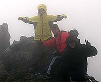
Climbing to the Summit: The summit of the dormant volcano that gives the park its name is, at 3,475 meters, the highest point in Panama. Those wanting to climb to the top of Barú will find the Boquete summit trail easier to manage than the one on the west side of Barú. When the road is in slightly less horrendous shape than normal, which means the dry season, it may even be possible to drive to the summit from this side. Even then, however, this requires a good four-wheel drive with a winch. The “road” more closely resembles a steep river bed. It’s an absolutely brutal drive and if you can make the hike it is really not worth it.
If you hike instead, allow at least 4-5 hours up and 3-4 hours back down. The hike is strenuous but not technically difficult. Remember, there’s a risk of hypothermia, especially for those who get stranded on the mountain, so be sure to bring warm, waterproof clothing.
Unless you’re looking for a marathon hike, drive or hire a taxi ($4) to the ranger station at the trailhead. A four-wheel drive is needed even to get this far. From Boquete, head north through town and take the second left past the church (look for the blue “Volcán Barú” sign). Continue straight past the first intersection then take the right fork uphill. There’s a fork after 6.7 kilometers. Take the right fork. The road forks again in about 800 meters. Take the left fork. After another 600 meters, take the right fork up the very steep gravel road.
The best way to do this excursion is to camp at kilometer 12, in Los Fogones area. Gear for rent, such as tents, sleeping bags and stoves can be found in downtown Boquete. The best time to be on the top of the Volcano is when the stars and moon fade away and the sun starts coming out. At dawn it is more likely to have a clear sky and see both oceans at the top.
Entrance is $3, payable at the little ranger station at the entrance to the park, which is in an area called Camiseta. There’s an outhouse at the station. It’s another $5 to camp in the park, but there are no facilities. From the station (elevation 1,840 meters) it’s another 13.5 kilometers to the top. The trail is fairly steep and very rocky. Those determined to start their trek in downtown Boquete should add another nine kilometers. |